Huge, Long-Range Plan For Downtown Rochester Waterfront Area

Rochester, MN (KROC AM News) - A proposed - and huge - transformational project for the southeast fringe of downtown Rochester will be presented to the City Council in a few weeks.
It was approved by the city Planning and Zoning Commission last week and is scheduled for a public hearing before the council on April 19.
Known as the Downtown Waterfront plan, it includes the area located between 4th St on the north and 9 ½ St on the south and Broadway on the west and 3rd Ave. on the east.
Included in the proposal: a 6th St bridge, housing and commercial development, replacing the rail line that runs through the area with a pedestrian walkway and a repurposing of the former AMPI plant, including the smokestack. City planners envision a 20 - 25 year timeline but note some significant portions could be carried out within the first 5 years, including the new bridge.
The city Community Development Department has given this title to the proposal:
Downtown Waterfront SE Small Area Plan.
The department’s description reads: “The Downtown Waterfront Southeast Small Area Plan is a shared community vision that addresses near- and long-term opportunities for change in a strategic area situated between downtown Rochester and the Slatterly Park and Sunnyside neighborhoods.”
Here’s more info on the proposal:
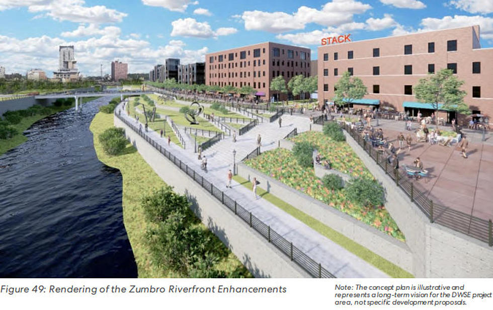
The plan features a mix of uses including office, commercial, neighborhood retail, as well as a wide range of housing types and choices. The adaptive reuse of the former AMPI brick bottling building and historic smokestack anchor the center (‘Stack District’) which is expected to act as a ‘hub’ for a variety of commercial, residential, and community-supportive uses in the new neighborhood.
Within the first five years, key public improvements should include the 6th St bridge as well as related riverfront modifications to support displacement within the river channel. At this time some riverfront improvements could also be made. With the bridge in place, 6th St could easily be connected to 3rd Ave and 1st Ave could be partially installed to support the AMPI site redevelopment and surrounding blocks.
Of the approximately 60 acres about 9 acres are proposed to remain as is including the Olmsted Medical Center, Olmsted Government annex as well as some office, restaurant, and residential uses.
Approximately 29 acres are proposed for private development. A proposed hotel connects south of the building via a glass atrium structure and mixed-use buildings enclose a brick paver courtyard. The signature smokestack will be preserved as a landmark and brand identity for the district.
The southeast quadrant of the project area features a ‘mews’ townhouse design that provides a level of starter and workforce (“missing middle”) housing that includes a mid-block walkable connection from the public park fronting 8th St and neighborhood scale retail and live/work units at 9th Street SE and 3rd Ave.
The “Stack District” represents the warehouse district organized around the former AMPI milk processing plant, a brick-faced industrial warehouse that is proposed for adaptive reuse as the “center” of the small area neighborhood. The building is envisioned to accommodate a variety of uses including events/gatherings, retail/commercial uses, and rooftop venues. A proposed hotel connects south of the building via a glass atrium structure and mixed-use buildings enclose a brick paver courtyard. The signature smokestack will be preserved as a landmark and brand identity for the district.
The North Project Area of the site is 4th St that will be home to the transit circulator station shown at the Government Center. The northern third of the project area will have the most intense development pattern including 8 and 10-story medical-related office uses. The east portion of the area facing 3rd Ave is reserved for affordably-priced neighborhood-scale residential development.
Complementing the riverfront enhancements, the plan envisions a pedestrian promenade in place of the existing rail line that runs north-south through the project area. The promenade would be lined with development along its eastern edge open toward the Zumbro River along its western edge, which would provide dramatic views of the Rochester skyline.
The proposed 6th St bridge over the Zumbro River is an important recommendation of the small area plan. The bridge has been historically identified as key infrastructure needed to improve connectivity, enhance emergency services response times, and drive economic development and neighborhood revitalization.
The northeast parcel (owned by Olmsted County) as well as portions of the former Kmart site, in particular the southeast corner, could be developed as soon as market demand can be supported as these sites have access and public street frontage.
The plan is anticipated to be realized over several phases and could take up to 20-25 years to be fully complete so it will be important to phase in key public infrastructure improvements in order to support the expected private investments.
The rate at which the recommendations are implemented depends on a combination of political will, funding availability, and market dynamics. Therefore, it will likely take many years (potentially decades) before the DWSE achieves the full vision outlined in the plan. Although the path to change is long, the first steps in the journey are critical because they not only need to be in the right direction but they also need to be taken right away after the completion of the planning process in order to capitalize on the positive energy and momentum of establishing a vision.
News update: I-90 detour near Stewartville to begin Monday.
FIVE THINGS YOU DIDN'T KNOW ABOUT MINNESOTA
More From Fun 104


